13:30 19.05.2026
Map of the Russian Federation with the Arctic zone and the Far East
The Arctic and the Far East cover 55 percent of the land area of the Russian Federation. Which regions are included in these zones?
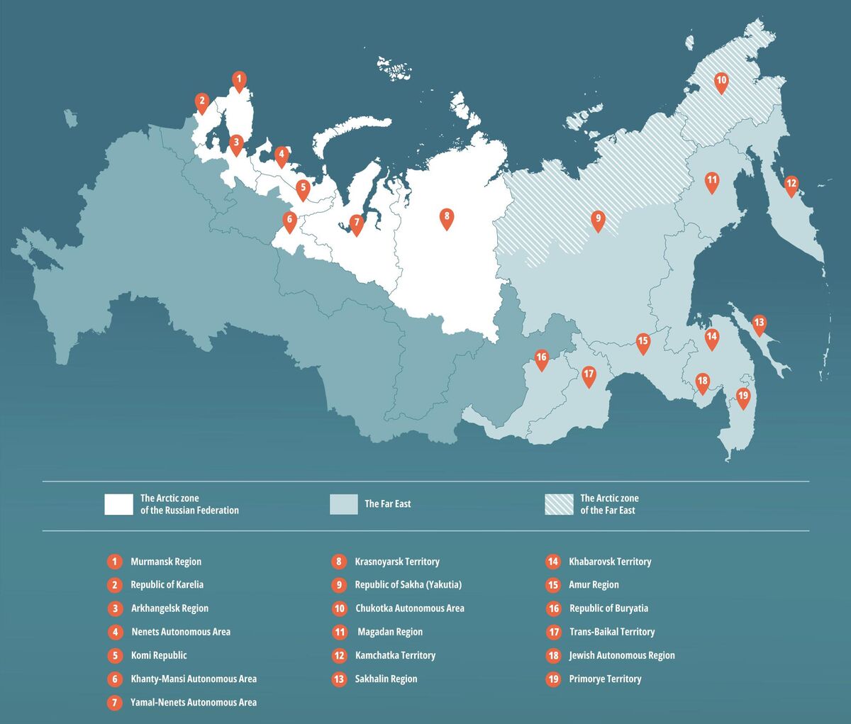
The land territories of the Arctic zone include:
- —Murmansk Region
- —Nenets Autonomous Area
- —Chukotka Autonomous Area
- —Yamal-Nenets Autonomous Area
- —Arkhangelsk Region: the cities of Arkhangelsk, Novodvinsk, and Severodvinsk; the Mezensky, Primorsky, Onezhsky, Leshukonsky, and Pinezhsky districts; and the Novaya Zemlya urban district
- —Krasnoyarsk Territory: Norilsk; the Taimyrsky, Dolgano-Nenetsky, and Turukhansky districts; rural settlements of the Evenkiysky municipal district: Surinda village, Tura village, Nidym village, Uchami village, Tutonchany village, Essey village, Chirinda village, Ekonda village, Kislokan village, Yukta village
- —Republic of Karelia: Belomorsky, Kalevalsky, Kemsky, Kostomukshsky, Loukhsky, Segezhsky districts
- —Republic of Komi: urban districts of Vorkuta, Inta, Usinsk; Ust-Tsilemsky District
- —Republic of Sakha (Yakutia): Abyysky, Allaikhovsky, Anabarsky, Bulunsky, Verkhnekolymsky, Verkhoyansky, Zhigansky, Momsky, Nizhnekolymsky, Olenyoksky, Srednekolymsky, Ust-Yansky, and Eveno-Bytantaysky districts
- —Khanty-Mansi Autonomous Area — Yugra: Beloyarsky and Berezovsky municipal districts
The Far Eastern Federal District is comprised of 11 constituent entities:
- —Primorye Territory
- —Khabarovsk Territory
- —Kamchatka Territory
- —Republic of Sakha (Yakutia)
- —Amur Region
- —Magadan Region
- —Sakhalin Region
- —Jewish Autonomous Region
- —Chukotka Autonomous Area
- —Republic of Buryatia
- —Trans-Baikal Territory